


Views of Old Countess Wear
When: 31 March 2019 to 31 October 2019
Where: Tea Room
Time: 1400 - 1700
Cost: No charge
Suitable for: Any age
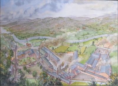
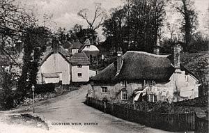
Have you ever wondered how Glasshouse Lane got its name? In the Museum Tearoom we currently have a collection of photographs, prints and orginal paintings of Countess Wear. Look for the limekilns on the beach and spot the glasshouses - 30 metre high cones where wine bottles were made and the furnaces were never allowed to cool. From mansions to thatched cottages, see wht Countess Wear looked like before people had cars.
The village like parish of Countess Wear was originally a part of Topsham. The village had gained some importance when it became the subject of a disputed weir in the thirteenth century, and as such, became the centre of disputes between Topsham and the City of Exeter. Although the church of St Luke's had been built in 1837-8 at a cost of £900, it was not until 1844 that it became a separate parish.
The area was named after Isabella de Fortibus, the Countess of Devon, who in the reign of Henry III, built the weir to power her mills. Subsequently, the salmon fishery at Exeter was damaged, causing friction between her successor, and cousin, Hugh Courtenay and the city. Hooker states that Hugh Courtenay deliberately blocked the gap with tree trunks between 1317 and 1327, and in effect, cut the port of Exeter off from the sea and enabled Topsham to steal the maritime trade of the Port of Exeter.
For more than 250 years the dispute dragged on, with the city petitioning the King to have the waterway reopened. In 1550, Edward VI granted permission for the weir to be breached, but it was too late; the river channel had silted up. Building the Exeter Ship Canal commenced in 1564 and opened in Autumn 1566, by John Trew. This was England's first canal with pound locks. Its original entrance was at Countess Wear, before the canal was extended further down the Exe estuary, initially in 1676 to Topsham, and to Turf Locks in 1827, to allow larger ships to enter.
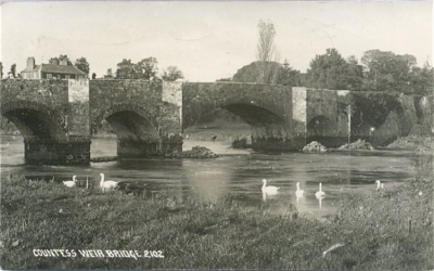
The road and river bridge bisects Countess Wear, with the main village to the north and the Glasshouse estate to the south. An Act for the road "... from Bear's Hill Oak Corner, in the Exminster Road, to the Red Post in the Topsham Road and building a bridge at the Ford at Countess Wear" was obtained and on 1st June 1769, the first planning meeting took place at the Salutation Inn, Topsham. The bridge was built of limestone at the lowest fording place of the river and opened on 14th September 1774. Despite the toll of 1 shilling for a coach and six horses, 10 pence for a score of oxen and a penny per person, it would not be until October 1874 that the last creditor would be finally paid off.
The Topsham Road which forms the traditional north-eastern boundary of the parish dating back to Roman times. It was an important route for pack horses and carts both before the canal, and also during the canal's working life. The road was first macadamedin 1819 when a contract was signed between the Turnpike Trust and Mr J L McAdam. Where the Wonford stream crosses the road at Northbrook a bridge was built in 1840.
Exhibition Gallery